
Project Overview
North-South Corridor
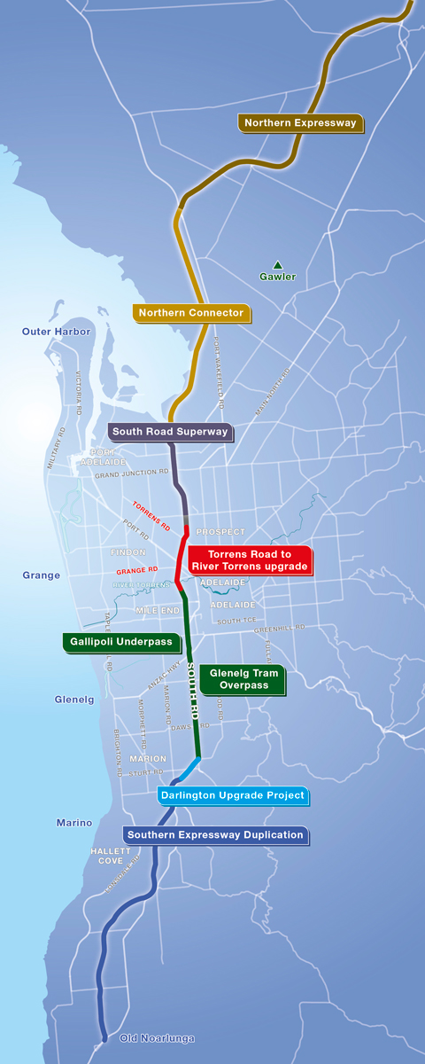 North-South Corridor map
The North–South Corridor is one of Adelaide’s most important transport corridors. It is the major route for north and south bound traffic including freight vehicles running between Gawler and Old Noarlunga, a distance of 78 kilometres, and is comprised of four road links:
- Northern Expressway from Gawler to Port Wakefield Road
- Northern Connector from Port Wakefield Road to Port River Expressway
- Main South Road from Port River Expressway to Southern Expressway; and
- Southern Expressway from Darlington to Old Noarlunga.
The Australian Government has announced its intention to upgrade the North–South Corridor over ten years and, together with the South Australian Government, has committed to construct the $754.5 million Darlington Upgrade Project. The Australian Government will contribute $603.6 million and the State Government $150.9 million for the Darlington Upgrade Project.
The upgraded North–South Corridor will provide a series of strategic free-flowing road links to connect the rapidly expanding industrial and residential growth areas in the north and the south, to provide new opportunities for economic development.
The current roadway isn’t capable of handling projected growth and the number of vehicles that need to use the road or the size of the freight carriers travelling along it. In response, Australian and South Australian governments are expanding the route by creating a dedicated non-stop North-South Corridor with a program underway to eliminate the worst bottlenecks.
To date, 44 km of the North–South Corridor has been completed. New road links have been built between Gawler and Port Wakefield Road (Northern Expressway), Regency Road and the Port River Expressway (South Road Superway) and between Bedford Park and Old Noarlunga (Southern Expressway duplication). Traffic flow along and across the route has also improved with the construction of the Gallipoli Underpass and the Glenelg Tram Overpass.
Project Timelines
| Project phase | Activities | Date |
|---|---|---|
| Concept planning and investigations |
| December 2013 to October 2014 |
| Pre-construction |
| October 2014 to late 2015 |
| Construction |
| Late 2015 to mid-2020 |
| Post-construction |
| mid-2020 onwards |