St Peters, Joslin Precinct Access Study
Fast facts

Status
Planning underway

Location
Northern Adelaide
The St Peters, Joslin Precinct Access Study covers the area bordered by Lower Portrush Road, Payneham Road, Stephen Terrace, and the River Torrens. The aim of the study is to assess road improvements to enhance safety, amenity, and local access for all users.
Precinct Access Study Area Map
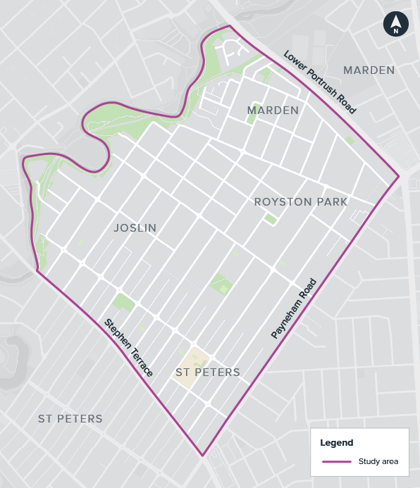
Study area map: Area bordered by lower Portrush Road, Payneham Road, Stephen Terrace and the River Torrens.
The key aims of the study are to:
- Assess traffic movement and requirements into and out of the study area.
- Evaluate the location and frequency of safe road crossings for people walking and riding.
- Assess bus movement across Stephen Terrace at Sixth Avenue.
- Align with the goals of the South Australian Transport Strategy for a safe, connected, accessible, liveable, sustainable and resilient transport system.
Community engagement
Consultation with the community was undertaken in October and November 2025. This included key stakeholder meetings and written submissions, an online survey, and two information sessions. Throughout the consultation period we connected with approximately 234 people, received a total of 450 online survey/interactive map submissions, and 7 written submissions.
The feedback received during the studies consultation period were reviewed for consideration and to find the key themes. Nine key themes were identified, highlighting the common priorities, concerns, and potential opportunities for improvement.
All feedback received has been reviewed, including the identified key themes, and summarised in the St Peters, Josling Precinct Access Study What We Heard Report.
Thank you to all members of the community who took the time to share their valuable feedback.
Study report
A Study Report is being prepared which will consider community feedback, site observations, assessment of crash statistics, analysis of traffic and speed data, accessibility to/from/along the arterial network (particularly pedestrians and cyclists) and road safety assessments. The final report will recommend a number of potential improvements for further consideration.
What's next
Any recommendations identified in the Study Report will necessitate further review and feasibility assessments, and will be subject to future funding considerations. Once a full report is prepared, the Department will collaborate with the Council regarding any proposed actions.
It is important we carry out these studies to enable us to plan for future infrastructure priorities.
Subscribe to project updates
Our privacy statement outlines what information we collect, how we use it and store it.
You can unsubscribe using the link in the email.